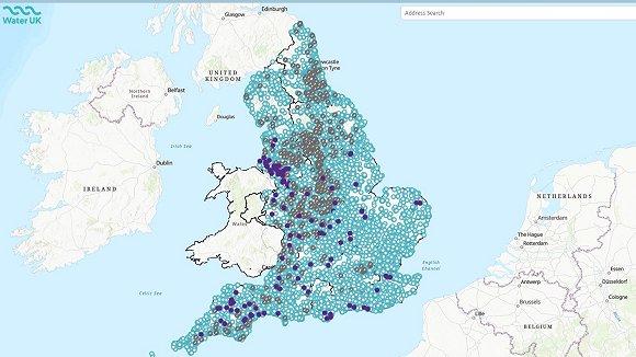
Water UK has introduced a groundbreaking interactive map that tracks the operation of every storm overflow across England. Starting today, recreational water users—including anglers, kayakers, and swimmers—can view, in real time, the specific locations and durations of storm overflow discharges.
The "National Storm Overflows Hub" will display data from all 14,187 storm overflows in the country. In addition to the map, the Hub provides a comprehensive FAQ section to educate the public.
This initiative was developed by Water UK, the trade body representing the UK's water industry, in collaboration with Stream, a cross-industry group promoting transparency, innovation, and the sharing of data. Expert advice from an independent steering group, which includes organizations such as the Rivers Trust, Surfers Against Sewage, and DEFRA, has shaped the creation of the Hub.
The Hub also offers information on the "National Storm Overflows Plan for England." This plan outlines the investment necessary to end sewage discharge into England’s rivers and seas. The initial phase of the plan proposes a near tripling of investment over the next five years, to £10 billion, with the goal of reducing storm overflow spills by 40% by 2030, pending approval by Ofwat.
The launch follows earlier releases of regional storm overflow maps by individual water companies. England now stands as the first country globally to achieve 100% monitoring of its storm overflow network.
An API has also been created to allow third parties, including charities and advocacy groups, to access and share the data on their platforms.
David Henderson, CEO of Water UK, stated: "England is the first nation to provide an interactive map displaying the operation of every single storm overflow, allowing everyone—from paddlers to swimmers—to track when and where overflows are active."
He added, “We are already the world’s most transparent water sector, and with £108 billion planned for investment over the next five years, we aim to ensure a secure water supply and end sewage pollution in our waterways, pending Ofwat’s approval.”
Rob Wilson, Chair of the Consumer Council for Water, emphasized that the interactive map is a crucial step toward greater transparency and rebuilding public trust in water companies.
Ben Seal, Head of Access and Environment at Paddle UK, representing the Clean Water Sports Alliance, welcomed the map's launch, noting that it marks significant progress in improving transparency and addressing pollution. However, he stressed the need for further steps to ensure that water users have all the information they need to make informed decisions.
This new resource represents a major advancement in monitoring storm overflows, but the journey toward cleaner water continues.
Read more here
View latest Water vacancies here


